>>
Technology>>
It service>>
NASA to launch a Space laser t...NASA to launch a Space laser to track the disappearing of ice sheets
The Silicon Review
17 September, 2018
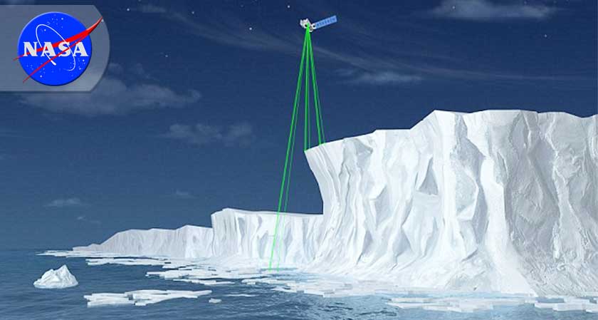
NASA is all set to launch a new satellite that will be used to monitor the planet’s glaciers, levels of ice as well as sea levels. What’s interesting is that this satellite, named ICESat-2 will be using space lasers to carry out its observations from orbit. It will be carrying a single giant laser coupled with an extremely precise altimeter to monitor the surface through the atmosphere.
The laser would be split into six beams divided into three pairs of two each, all of which would pass over a designated area. Additionally, the satellite also carries a telescope to capture the reflections of the lasers, just a few photons from each beam. This process of beaming and capturing the reflections is done thousands of times each second to gather accurate data. Combined with its altimeter, laser, and telescope, this satellite would be able to detect millimeter variations in the levels of ice sheets over a period of time. In addition to ice sheets, the ICESat-2 can measure the heights of buildings and other structures with a very high degree of precision.
The launching of this futuristic satellite comes at a time when climatic changes continually cause widespread destruction in the form of recurring hurricanes, tornados or excessive rainfalls leading to massive floods. Monitoring of phenomenon such as changes in polar ice sheets could enable climatologists to better understand climatic changes and their effects.
Furthermore, the ICESat-2 is set to be launched on a Delta II rocket, which would be the last launch of the robust 30-year-old rocket.
MOST VIEWED ARTICLES
RECOMMENDED NEWS


TOP NEWS
YOU MAY ALSO LIKE