>>
Other>>
Infrastructure and development>>
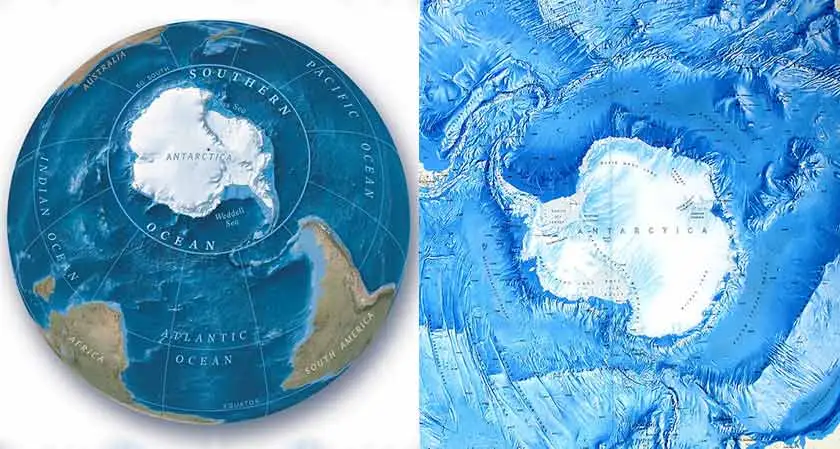
Scientists have created the mo...INFRASTRUCTURE AND DEVELOPMENT
Scientists have created the most comprehensive map of the Southern Ocean Floor
The Silicon Review
08 June, 2022
Author:
The Silicon Review Team
Knowledge of the physical geography of the ocean floor is key to safe navigation
Scientists have succeeded in making a comprehensive map of the Southern Ocean encircling Antarctica. The map is the most accurate one yet of the canyons, mountains, and plains that make up the Southern Ocean floor. Covering 48 million sq. km, the map details a new deepest point lying at 7,432m, called the Factorian Deep. Knowledge of the physical geography of the ocean floor is key to safe navigation, marine conservation, and also understanding Earth’s climate and geological history. This endeavor of creating the International Bathymetric Chart of the Southern Ocean (IBCSO) has taken five years to compile.
The IBCSO project and other such projects are throwing more light on understanding the world’s ocean floors. Vast tracts of terrain still remain in the dark and have not been adequately surveyed. Ships and boats are routinely encouraged to turn on their sonar devices to get bathymetric measurements. The new map covers an area poleward of 50 degrees south. Earlier, areas only 60 degrees South were covered on the map. This is a considerable improvement. Much of the information that played a crucial role in creating this map comes from ships that shuttle back and forth between the Continent. UK’s former polar ship RRS James Clark Ross is one among them.